Greenway Trails
Getting There & Parking
Features as You Walk
More Trails
Our 'You are Here' Map
Interpretive Information
Directions from your location to particular parking areas along the Greenway are provided with the assistance of GPS Coordinates. Lots with washroom facilities are indicated.
Visiting Phase 1 (the 8 km of the Greenway closest to Okanagan Lake):
Visiting Phase 2 (the Greenway 8 to 16 km from Okanagan Lake):
Visiting Phase 3 (under construction):
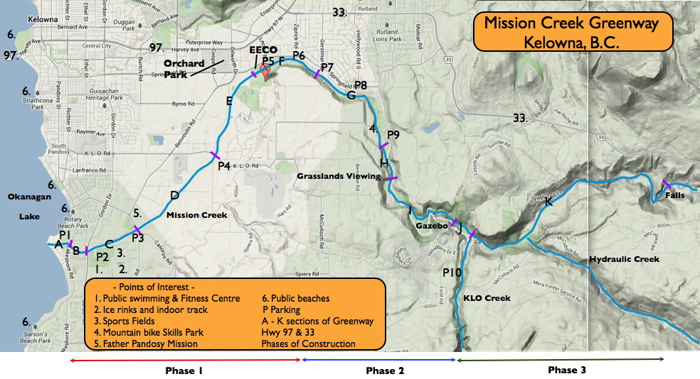
Visiting Phase 1 of Greenway (Getting there & Parking):
P1. Cook Rd Parking. Washrooms:Latitude N49 50.724, Longitude W119 29.301
P2. Lexington Rd Parking. Washrooms:Latitude N49 50.522, Longitude W119 28.633
P3. Casorso Rd/Swamp Rd. Parking:Latitude N49 50.686, Longitude W119 27.992
P4. KLO Rd Parking:Latitude N49 51.614, Longitude W119 26.599
P5. EECO Parking. Washrooms:Latitude N49 52.647, Longitude W119 25.853
P6. Ziprick Rd Parking:Latitude N49 52.653, Longitude W119 25.857
Visiting Phase 2 of Greenway (Getting there & Parking):
P7. Gerstmar Park. Washrooms:Latitude N49 52.632, Longitude W119 24.527
P8. Hollywood Rd Parking:Latitude N49 52.371, Longitude W119 23.877
P9. Hollywood Rd South Parking. Washrooms:Latitude N49 51.853, Longitude W119 23.358
P10. Field Rd Parking. Portable Outhouse:Latitude N49 50.357, Longitude W119 22.105